Lightning struck a 60-foot sequoia tree on Oakmont Drive in Santa Rosa Friday morning around 5 a.m., exploding the upper half and sending debris flying 200 feet in all directions.
The blast damaged two adjacent buildings — the Monsignor Fahey Parish Center and a Sonoma County emergency services office. The church received a red tag prohibiting entry, while the emergency office got a yellow tag restricting access pending inspection. No injuries were reported.
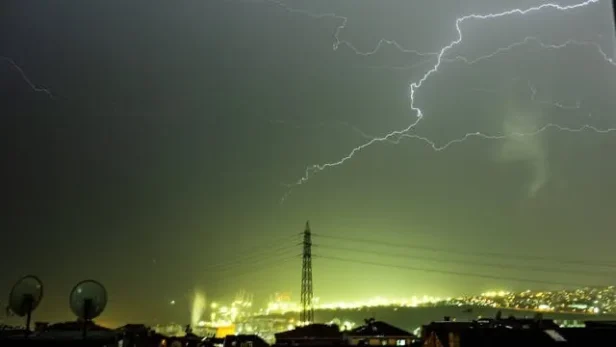
“There was a boom, then a crack. The loudest thunder I’ve ever heard,” David Morgan, who lives across the street, told KTVU. “It gets scary right away — there are so many trees like that around here.”
Oakmont resident Caureal King also woke to the explosion. “The loudest thunder in 45 years living on the West Coast,” she said. “The sky was all lit up.” Heavy rain at the time prevented burning embers from spreading.
The lightning strike was part of a three-day storm system that pummeled Northern California and the Bay Area from Thursday through Sunday. Two weather systems — a Pacific cyclone and a cold front from the Gulf of Alaska — combined to create unusually powerful April thunderstorm activity.
Saturday brought the worst conditions. The National Weather Service warned of wind gusts up to 50 mph, small hail, isolated tornadoes and waterspouts. The storm front moved north to south, hitting San Francisco, San Mateo, Redwood City, Novato and Fairfax. Activity began subsiding Sunday, with NWS forecasting scattered showers and isolated thunderstorms before conditions improve Monday.
The Bay Area received between half an inch and 1.5 inches of rain over three days. Coastal mountains saw up to three inches. The North Bay took the heaviest hit, with more than an inch falling Friday night.
High wind warnings affected the Bay Bridge. Caltrans advised RVs, trailers and oversized vehicles to avoid the span.
Mountain conditions proved far more severe. NWS issued Winter Storm Warnings across the entire Sierra Nevada range from Lassen County north to Sequoia National Park south. Forecasters predicted one to five feet of snow above 6,000 feet elevation, with ridge winds gusting to 90 mph.
April snow — known as “Sierra Cement” — falls heavy and wet. Combined with high winds, it topples trees and snaps power lines.
Interstate 80 through Donner Pass operated Saturday under strict restrictions. Chains were mandatory from Cisco Grove to Donner Lake Interchange eastbound, and from Truckee to the SR-20 junction westbound. Trucks faced inspections at Applegate, Truckee and five miles west of Reno.
Complete closure of I-80 Saturday night was the most likely scenario, Caltrans said. A similar February storm shut the 60-mile stretch from Colfax to the Nevada border, stranding hundreds of vehicles for hours.
Highway 50 to Echo Summit and SR-20 near Nevada City also faced potential closures. Caltrans advised against mountain travel until Monday, when crews can clear the passes.
The storm hit nearly bare mountains. April 1 measurements showed Sierra Nevada snowpack at 18% of normal — the second-lowest on record. The Northern Sierra registered just 6% of normal. March 2024 was the warmest and driest in recorded history.
California needs the snow as water storage for summer. But for weekend Tahoe visitors, it meant closed roads, zero visibility and mountains belonging to the storm.
Temperatures in the Bay Area will return to the 70s by next Friday. But officials recommend staying home until Monday.